 Slovenski INSPIRE metapodatkovni sistem
Keyword
mathematical elements, settlements and objects, communications, relief, hydrography, land cover, borders, geographical names, images/base maps/land cover
1 record(s)
Type of resources
Categories
INSPIRE themes
Keywords
Contact for the resource
Scale
From
1
-
1
/
1
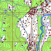
-
A brief description: National Topographic Map at 1 : 50 000 scale - vector data (DTK 50V) is an object-oriented cartographic database (vector elements). The objects are categorized into eight object groups: - mathematical elements - settlements and facilities - communications - relief - hydrography - land cover - boundaries and dividing lines - geographical names. DTK 50V is from 2017 available also as a seamless vector cartographic set of data, which is maintained as SHP files (46). SHP files are also available for the users. The data of the vector DTK 50 are used for spatial planning, for field orientation purposes, as a basis for other topics and as a source for the production of different maps.